ESurvey CADD is a collection of to meet all the requirements related preparation of drawings and reports related to site, road, canal, railway & infra projects. ESurveying Products offer solutions for creation of drawings related to contours, computing earth work, preparing cross section and longitudinal section, interpolation, traverse correction, horizontal and vertical curve design, calculation of soil based quantities in irrigation projects, etc.
Contours:
Contours can be defined as the line of intersection of a level surface with the ground surface. Our Contouring software “ESurvey Contours” allows you to quickly generate smooth Contours from point data. This sub-section is further divided into 10 chapters and takes you through an in-depth understanding of the software.
Creating contour map with point data, Annotating contour, Generating grid levels, Preparing contour surface in 3D, Preparing contour based area and volume reports, Creating alignment on a contour surface.
Earthwork:
Earthworks are engineering works created through the moving and/or processing of massive quantities of soil or unformed rock. Earthwork is done for reconfiguring the topography of a site to achieve the design levels. “ESurvey Earthwork” helps you in volume calculations and section drawings from point data available in CAD drawings / levels available in Excel or CSV files. This sub section gives a detailed description of this software in 9 different chapters.
Generating earthwork report with given formation level. Generating earthwork report for 2 earthwork surfaces. Generating earthwork report for a ground surface and estimated 3d surface. Generating earthwork with section on block method. Earthwork calculation for different depth of cut or height of filling.
TopoMap:
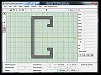
A topographic map is a large-scale map showing relief and man-made features of a portion of a land surface distinguished by portrayal of position, relation, size, shape, and elevation of the features. “ ESurvey TopoDraw” allows you to generate Topographical drawings from point data instantly with blocks and elevations in their respective Northings and Eastings. This sub section has 6 chapters to explain the usage of ESurvey TopoDraw.
Convert Total Station Data to AutoCAD Drawing. Automating drawing creation for Automatic Line Joining, Inserting Remarks & Blocks, Layerisation.
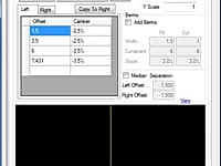
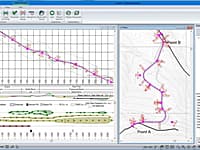
Sections:
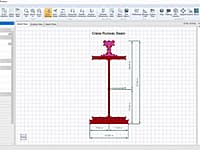
Section drawings are obtained by using sectioning technique, the object is imagined to be cut by a plane and the portion nearer to the observer is imagined to be removed. This way, the interior is exposed and drawn as a sectional view. The section can be a longitudal or Cross section. “ESurvey Sections” is a complete section creation and management solution designed to help surveyors, engineers and designers to create industry standard drawings. This sub section gives a detailed description of this software package in 9 different chapters.
Interpolate:
Interpolation ESurvey Interpolate” enhances this software by providing you with an easy way to interpolate points at any intervals using the actual surveyed data for generating Cross-sections along the Longitudinal-sections. This sub section gives a detailed description of the software package in 6 different chapters.
KML:
Google Earth is a geo-browser which represents the Earth as a three dimensional globe. It is a great tool to Explore Earth Imagery. On the other side CAD Package which works with UTM is more convenient to represent 2-D Drawings. Converting data available in Google Earth in the form of KML File to 2 Dimensional drawing data and Vice Versa is possible with ESurvey KML. This sub section gives a detailed description of this software package in 6 different chapters.
Lisps:
Lisp is a family of computer programming languages which allows you to store and manipulate programs in the same manner as any other data, making it well suited for using with other applications. "ESurvey Lisps" is a collection of lisp routines developed exclusively for CAD users working on Survey drawings. This software is developed to allow you to save time in searching for suitable lisps online and thus speeds up your drawing creation. This subsection is divided into 18 chapters to give a detailed description of each of our documented lisp categories.
* ESurvey CADD download link provides trial version of the software.
Design and analysis of custom cross section profiles
CADRE Profiler is used to design section profiles and determine their geometric properties for custom beam cross sections which can be composed of different materials
Earthwork Volume/Quantity Calculating
AEC CutFill is a powerful and flexible earthwork cut and fill calculation software program.
Earthwork Optimization for Corridor Projects
Standalone road and corridor optimization tool. Works with designs created in other design software.
ShapeBuilder calculates geometric section properties, like area, moment of inertia, etc.
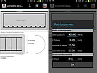
Determine The Amount of Reinforcement in a Concrete Section
Civil engineering app to determine the amount of reinforcement in a concrete section for preliminary design.

Submit a review about ESurvey CADD software with your social media profile