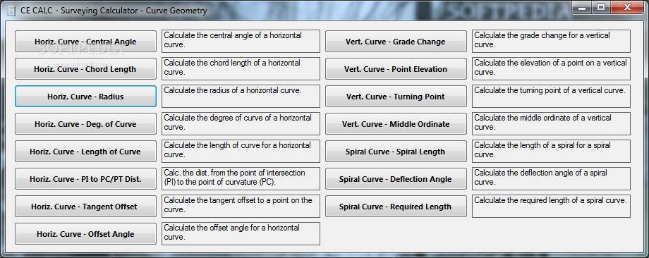
Stand alone software version of the surveying and earthwork portion of the CE CALC website. Runs on the Windows . NET platform. Performs civil engineering calculations for traffic/road geometry, surveying/earthwork, pavement, concrete floors and unit conversions.
- Latitudes and departures
- Azimuths
- Traverse leg distance
- Area measurement by coordinate method
- Topographic surveying - instrument height, level sighting point elevations and inclined sighting point elevations
- Earthwork volume - average end area earthwork volume and grid square method earthwork volume
- Stadia distance measurement - level sighting stadia distance and inclined sighting stadia distance
* Surveying Calculator download link provides trial version of the software.
Performs civil engineering calculations for hydrology, open channels, culverts, gravity sewer, transmission lines and unit conversions.
Stand alone software version of the pavement design portion of the CE CALC website. Runs on the Windows . NET platform. Performs civil engineering calculations for traffic/road geometry, surveying/earthwork, pavement, concrete floors and unit c

Civil Engineering Calculations
Performs civil engineering calculations for hydrology, open channels, culverts, gravity sewer, transmission lines, traffic/road geometry, surveying/earthwork, pavement, concrete floors and unit conversions.

Design For Survey, Town Planning & Industrial Plants And Tunneling
The largest and versatile software for survey, dtm, contouring, site development for township, tunnel, airport, irrigation, water supply projects.
Surveying, Civil and Water Engineering
Distributed in over 60 countries & on the market for over 20 years, 12d Model is a proven world leader in civil engineering, water engineering & land surveying software.
Submit a review about Surveying Calculator software with your social media profile
No comments yet. Be the first to comment.