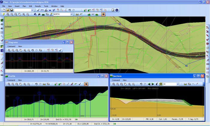
Diolkos is a complete and robust solution for designing all types of road projects in a visual multifunctional 3D environment. Its design capabilities are not limited to road projects but it can be used in any type of corridor facilities as well (railways, airfield runways, channels etc. ).
Main features
- All Cases of Road Design
- 3D Visualization
- Digital Terrain Models (DTMs)
- RAS-AASHTO Guidelines
- Typical Cross Sections Library
- Multiple Road Projects
- River analysis
- Quantities Measurements
Capabilities
- Slightly integrated with Direct3D, one of the most powerful graphic acceleration engine.
- Separate application (FastTerrain) able to create, edit and project in 3D space digital terrain models (DTMs). Involves very fast constrained delaunay triangulation and contour calculation algorithms. Breaklines and holes insertion. Filters for points, breaklines and 3d faces. Insertion / Exportation from/to text XYZ or DXF files.
- RAS, AASHTO and OMOE guidelines. Design for plan, profile, diagrams, cross sections, earthwork volumes, quantities measurement. OMOE consistency checks.
- Design diagrams for superelevation rate, pavement widenings, V85 and drainage layer.
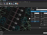
- Quick and easy insertion and modification of project's geometry. Real time 3d presentation of the project (for simple or multiple road projects). Real time 3d animation along the road axis. Checks for the final stopping sight distance along the road axis.
- Survey terrain from set of 3d faces (TIN) or 3d lines (e. g contour lines). Incidentally shape definition for fills and cuts side slopes. Upgrading design adjacently to existing road pavement. Calculation for drainage layers, capping layer, regulating course layer, benching, soil replacement cuts , walls and guardrails.
- Visual typical cross section definition, material assigning. Extensive build-in typical cross section library.
- Quick calculation for all cross sections at every plan modification. Automatically stations insertion and reconstruction of the Road-Terrain 3d model when plan geometry changes.
- Multiple road projects (service roads, intersections). Modification of each road independently from its direction. Road axis editing regardless stations projection between parallel roads.
- Swept paths calculation in order to study vehicle turning maneuvers in sharp curves.
- Design of hydraulic channels of random shape cross sections. Study of existing riverbed, water supply scaling, calculation of water cover areas. Drawing production according to the hydraulic project requirements.
- Quantities measurements during the construction stage (Import/Export via text files). Free insertion or modification (via mouse or keyboard) of cross sections lines. Utilities for automatically layer creation based on quantities measurements during the construction stage.
- On line CAD drawings production with Microsoft ActiveX automation technology or with DXF files.
- Simply project manipulation. All the design data are stored in a single file. Free product support from specialist civil engineers with great experience in road and hydraulic projects.
* Diolkos download link provides demo version of the software.
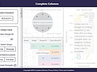
Reinforced Concrete Column Design and Grouping Optimisation
Complete Columns is a cloud-based structural engineering reinforced concrete column design and grouping optimisation software.
RoadEng is a site and road design software package. It works either as an add-on to other civil design software or as a standalone system. It includes functions for data collection, terrain modelling, contouring, volumes, profiles, sections, and road design.
Site and Road Engineering 3D Design
Site3D is a fully featured software product for the engineering design of road systems and housing developments.
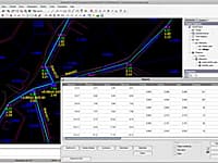
The WaterNET-CAD is software product that can be used in order to create, edit and analyze any kind of sewer, water distribution, storm or vacuum sewer network facility.
RDS is a low cost infrastructure software dedicated to companies to carry out all categories of linear projects such as road projects, pipeline network projects and sewage network projects.
Submit a review about Diolkos software with your social media profile
No comments yet. Be the first to comment.