RDS screenshot
SOFTWARE :RDS
DEVELOPER :BAKHTI Software
VERSION :2021
PLATFORM :Windows
FILE SIZE :9.41 MB
LICENSE :Trial
DOWNLOADS :UserDownloads:240
Program Description

RDS is a low cost infrastructure software dedicated to companies to carry out all categories of linear projects such as road projects, pipeline network projects and sewage network projects. Our software has a simple, intuitive interface and gives the user great flexibility to design linear projects

RDS includes functions for:

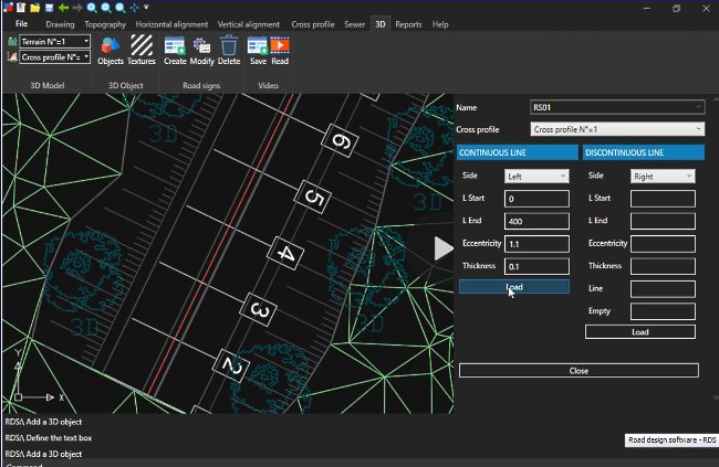
  • 3D presentation videos of your road project (mp4 format);
  • Import topographic points from several file formats (TXT, XYZ and DXF);
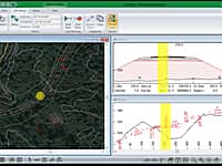
  • Import 3D points from Google Maps;
  • Digital terrain model & contour lines ;
  • Identify and model breaklines;
  • Identify and model contours;
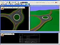
  • Geometric Road Design (Horizontal alignment, Vertical alignment and Cross Sections);
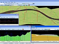
  • Unique mode for displaying the vertical alignment;
  • Display the horizontal alignment in a mini-window (vertical alignment mode);
  • Real time calculation of cross sections;
  • Project export to DXF format;
  • Pipeline networks design;
  • Sewer networks design.

Our software consists of:

  • Land survey
  • Horizontal alignment
  • Vertical alignment
  • Cross section
  • Sewage network
  • 3D projects Demonstration

* RDS download link provides trial version of the software.

Similar Software
RoadEng Version:9.0 · Softree
RoadEng

Road Design Package

RoadEng is a site and road design software package. It works either as an add-on to other civil design software or as a standalone system. It includes functions for data collection, terrain modelling, contouring, volumes, profiles, sections, and road design.

Site3D Version:4.5 · Microplot Ltd
Site3D

Site and Road Engineering 3D Design

Site3D is a fully featured software product for the engineering design of road systems and housing developments.

Diolkos Version:10 · Diolkos3D
Diolkos

Complete and Autonomous Road Design

Diolkos is a complete and robust solution for designing all types of road projects in a visual multifunctional 3D environment.

Civil Designer Version:8.4 · Civil Designer
Civil Designer

Civil Infrastructure Design Suite

Civil Designer software gives you an integrated civil infrastructure design suite of modules incorporating bulk earthworks, highways, roads, surface drainage, wastewater drainage and potable pressurized water network design and analysis, in a single application.

Grapher Version:17.2 · Golden Software
Grapher

2D & 3D Graphing

Grapher is the only graphing program you will ever need. Create powerful stunning graphs quickly and efficiently. Ideal for scientists, engineers, and business professionals.

Comments & Reviews

No comments yet. Be the first to comment.

Submit a review about RDS software with your social media profile

avatar
Rate This Software

No one has rated RDS yet. Be the first to rate this product.

Popular Programs

6287 hitsPavement Calculator 2.0

Stand alone software version of the pavement design portion of the CE CALC website.   Runs on the Windows . NET platform.   Performs civil engineering calculations for traffic/road geometry, surveying/earthwork, pavement, concrete floors and unit c

3577 hitsRoadEng 9.0

RoadEng is a site and road design software package. It works either as an add-on to other civil design software or as a standalone system. It includes functions for data collection, terrain modelling, contouring, volumes, profiles, sections, and road design.

2912 hitsAI SW-1 Thickness Design 1.0.5

An integrated pavement design suite for highways, streets, parking lots, airports, and industrial facilities supporting heavy wheel loads.

2221 hitsPAVEXpress 2020

PaveXpress is a free web-based pavement design tool available for use by local agencies, engineers and architects who need a reliable way to quickly determine the necessary pavement thickness for a given section of roadway or project.

New & Updated

21 NovFAARFIELD 2.1

FAARFIELD, the FAA’s standard software for airport pavement thickness design and evaluation (AC 150/5320-6G, Airport Pavement Design and Evaluation) and pavement strength reporting using the ACR/PCR method.

26 FebPerRoad 4.4

PerRoad is a mechanistic-based procedure for the design of flexible long-life or perpetual pavement structures.

1 JanPAVEXpress 2020

PaveXpress is a free web-based pavement design tool available for use by local agencies, engineers and architects who need a reliable way to quickly determine the necessary pavement thickness for a given section of roadway or project.

27 NovITETripGen 2020

ITETripGen enables development of estimates of motor vehicle, pedestrian, transit user, bicyclist, and truck trips, generated by a land use based on its characteristics and setting.