PMWIN screenshot
SOFTWARE :PMWIN
DEVELOPER :Simcore Software
VERSION :5.3.3
PLATFORM :Windows
FILE SIZE :15.74 MB
LICENSE :Freeware
DOWNLOADS :UserDownloads:3698
Legacy Software Notice:
Please be advised that PMWIN is considered outdated or legacy, and it has reached the end of its support and update cycle. As a result, compatibility issues may arise, and its functionality cannot be guaranteed on modern computer systems.
Program Description

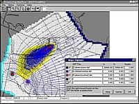
PMWIN is one of the most complete groundwater simulation systems in the world.  PMWIN simulates the groundwater flow within the aquifer is simulated in MODFLOW using a block-centered finite-difference approach. Layers can be simulated as confined, unconfined, or a combination of both. Flows from external stresses such as flow to wells, areal recharge, evapotranspiration, flow to drains, and flow through riverbeds can also be simulated.  

Processing Modflow (version 5.3) is included in the first edition of the book "3D-Groundwater Modeling with PMWIN" published by Springer-Verlag (ISBN 3-540-67744-5). Processing Modflow 5. 3. 3 is an update that runs under Windows XP and Windows 7.

* PMWIN download link provides freeware version of the software.

Similar Software
Processing Modflow Version:11.0 · Simcore Software
Processing Modflow

Groundwater Modeling System

Processing Modflow (PMWIN) is a comprehensive integrated groundwater modeling system that is used by many organizations, such as research institutions, consulting firms, agencies, and entities of the United Nations.

MODFLOW Core Version:6.2.1 · USGS
MODFLOW Core

Modflow-2005 and Modflow 6

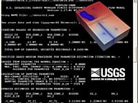
MODFLOW is considered an international standard for simulating and predicting groundwater conditions and groundwater/surface-water interactions.

MODFLOW-USG Version:1.5 · USGS
MODFLOW-USG

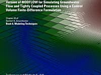
An Unstructured Grid Version of MODFLOW

An unstructured grid version of modflow for simulating groundwater flow and tightly coupled processes using a control volume finite-difference formulation

Seer3D Version:2.11 · Simcore Software
Seer3D

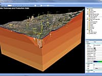
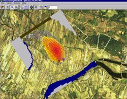
Visualization of Field Measurement Data and Groundwater Model Results

Seer3D is an application for the visualization of field measurement data and the groundwater model results. It includes powerful tools for displaying vector and raster maps, presenting wells, boreholes, lithological, and geophysical data.

SeismoSignal Version:2021 · SeismoSoft
SeismoSignal

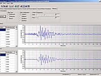
Processing of strong-motion data

SeismoSignal constitutes an easy and efficient way to process strong-motion data, featuring a user-friendly visual interface and being capable of deriving a number of strong-motion parameters often required by engineer seismologists and earthquake enginee

Comments & Reviews
Clauphat Ossete
★★★
Je suis en difficulté pour inserer la carte de fond format jpeg sur pmwin

Submit a review about PMWIN software with your social media profile

avatar
Rate This Software

PMWIN has been rated 2.6 out of 5 points. A total of 8 votes cast and 1 users reviewed the software.

Popular Programs

9025 hitsHEC-RAS 6.0

HEC-RAS is designed to perform one-dimensional hydraulic calculations for a full network of natural and constructed channels.

3834 hitsHEC-HMS 4.7.1

The Hydrologic Modeling System (HEC-HMS) is designed to simulate the complete hydrologic processes of dendritic watershed systems.

3297 hitsAquiferWin32 6.0

Aquifer test analysis is an integral part of groundwater modeling, supplying critical hydraulic parameters to the model or other basic groundwater calculations.

1468 hitsProcessing Modflow 11.0

Processing Modflow (PMWIN) is a comprehensive integrated groundwater modeling system that is used by many organizations, such as research institutions, consulting firms, agencies, and entities of the United Nations.

New & Updated

24 DecSMS 13.1

SMS (Surface-water Modeling System) is a complete program for building and simulating surface water models from Aquaveo.

10 DecWMS 11.1

Aquaveo WMS (Watershed Modeling System) is a watershed computer simulation and modeling software application from Aquaveo. WMS is a all-in-one hydrologic and hydraulic solutions and pipe network tools.

3 DecGMS 10.5

GMS (Groundwater Modeling System) is water modeling application for building and simulating groundwater models from Aquaveo.

12 MarGSFLOW 2.1

GSFLOW is a coupled Groundwater and Surface-water FLOW model based on the integration of the USGS Precipitation-Runoff Modeling System (PRMS-V) and the USGS Modular Groundwater Flow Model (MODFLOW-2005 and MODFLOW-NWT).