CESDb > Water Resources > Well Logger
Well Logger screenshot
SOFTWARE :Well Logger
DEVELOPER :Porpoise Media
VERSION :3.0.1
PLATFORM :Windows
FILE SIZE :7.15 MB
LICENSE :Trial
DOWNLOADS :UserDownloads:1306
Program Description

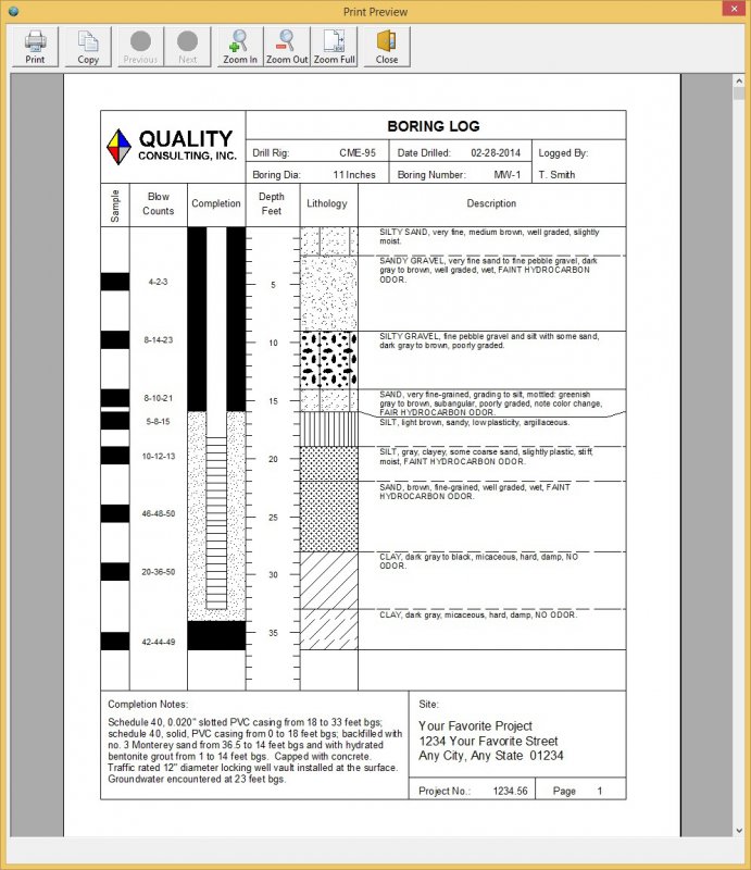
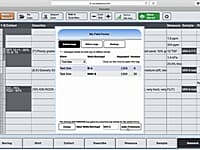
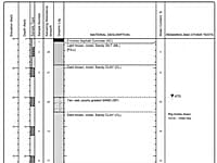
Well Logger software lets you create soil boring logs and well construction diagrams. It boasts a simple, yet robust, user interface that features customizable layouts, user-definable fill patterns, adjustable scaling, and print preview.

Well Logger has an easy-to-use spreadsheet interface, with drop-down lookup boxes to simplify data entry for each borehole. Entry information includes borehole lithology, samples collected, well construction or borehole backfilling details, and general information about the project and boring. Well Logger can produce your boring and well logs in half the time of traditional CAD style programs.

Project engineers and geologists can use Well Logger on a laptop at the worksite to quickly complete necessary documentation -- usually during available drilling downtime.

* Well Logger download link provides trial version of the software.

Similar Software
SO-Log Version:1.2 · Soil Office
SO-Log

Geotechnical Engineering Boring Logs

SO-Log generates boring logs as a means to summarize and report several tests performed within a geotechnical engineering project.

GeoWell Editor Version:2016 · Porpoise Media
GeoWell Editor

Production Of Geo_Well Data Files

The GeoWell Editor is a stand-alone editor that simplifies the production of GEO_WELL data files for submission to California’s GeoTracker system.

WinLog Version:4.0 · GAEA Technologies
WinLog

Boring, Borehole and Well Logs

The WinLoG extension module of GaeaSynergy can be used to quickly and easily create, edit and print boring logs, borehole logs and well logs for a variety of industries.

LOGitEASY Version:2020 · ICD Services
LOGitEASY

Create Boring Logs Online

LOGitEASY provides a free online service (Free Logs) for creating report-quality boring logs.

BorinGS Version:4.8 · Gookin Software
BorinGS

Drafting of Boring and Well-Completion Logs

BorinGS is a software for drafting boring logs and well-completion logs. BorinGS gives you high quality output with customizable columns, hatch patterns, and page layouts.

Comments & Reviews
Zac Hawk
★★★★
The program is easy to use the logs just are ugly.
Abo Kossay
★★★
I need tutorial please
Peter Howitz
★★★★★
Well Logger is clearly the easiest and most straight forward to generate borehole and well logs. Using Well Logger, I was able to create and print a borehole log in 10 minutes, the very first try!

Submit a review about Well Logger software with your social media profile

avatar
Rate This Software

Well Logger has been rated 3.6 out of 5 points. A total of 5 votes cast and 3 users reviewed the software.

Popular Programs

9025 hitsHEC-RAS 6.0

HEC-RAS is designed to perform one-dimensional hydraulic calculations for a full network of natural and constructed channels.

3834 hitsHEC-HMS 4.7.1

The Hydrologic Modeling System (HEC-HMS) is designed to simulate the complete hydrologic processes of dendritic watershed systems.

3698 hitsPMWIN 5.3.3

Processing Modflow version 5. 3 is included in the first edition of the book 3D-Groundwater Modeling with PMWIN published by Springer-Verlag.

3297 hitsAquiferWin32 6.0

Aquifer test analysis is an integral part of groundwater modeling, supplying critical hydraulic parameters to the model or other basic groundwater calculations.

New & Updated

24 DecSMS 13.1

SMS (Surface-water Modeling System) is a complete program for building and simulating surface water models from Aquaveo.

10 DecWMS 11.1

Aquaveo WMS (Watershed Modeling System) is a watershed computer simulation and modeling software application from Aquaveo. WMS is a all-in-one hydrologic and hydraulic solutions and pipe network tools.

3 DecGMS 10.5

GMS (Groundwater Modeling System) is water modeling application for building and simulating groundwater models from Aquaveo.

12 MarGSFLOW 2.1

GSFLOW is a coupled Groundwater and Surface-water FLOW model based on the integration of the USGS Precipitation-Runoff Modeling System (PRMS-V) and the USGS Modular Groundwater Flow Model (MODFLOW-2005 and MODFLOW-NWT).