CESDb > Developers > Underhill Geomatics
Underhill Geomatics

Underhill & Underhill are Vancouver BC land surveyors providing full-service land, construction, and engineering surveying with 3 offices in Western Canada

CESDb currently lists 2 software developed by Underhill Geomatics, including Copan Pro, Copan Pro For Android.

You can also visit developers official website http://underhill.ca for software support, product updates, licenses and other information.

Software by Underhill Geomatics
Copan Pro Version:12.02 · Hit:1134
Copan Pro

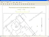
Computing and Managing Plane Land Survey Coordinates

Copan Pro is a very functional and user-friendly desktop/netbook geomatics engineering tool for computing and managing plane land survey coordinates and for drafting and plotting survey maps and plans/plats.

Copan Pro For Android Version:1.3 · Hit:602
Copan Pro For Android

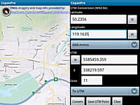
Hand-held Geomatics Engineering Tool

Copan Pro for Android is a hand-held geomatics engineering tool for computing and managing plane land survey coordinates.

Similar Software From Other Developers
HEADS Pro Version:24 · Techsoft Engineering Services
HEADS Pro

Highway Engineering and Design Application

The simplestand versatile software for highway engineering and design with special features for low cost rural roads and hill roads, tunnels.

SketchUp Pro Version:2021 · Trimble Navigation
SketchUp Pro

3D modeling for Architectural, Interior Design and Civil Engineering

SketchUp Pro is the most intuitive way to design, document and communicate your ideas in 3D.

ASTRA Pro Version:24 · Techsoft Engineering Services
ASTRA Pro

Analysis & Design of Bridges with Foundations, Hydrological Analysis, Culverts, Underpasses

The simplest and versatile software for structural analysis and design of bridges with super structures, sub structures, foundations, hydrological analysis, culverts, underpasses.

Nonio C & DomusTerra Version:10.5 · Interstudio
Nonio C & DomusTerra

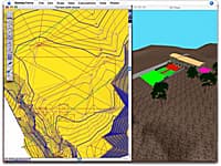
Surveys, Land Modeling, Landscape

Nonio C is a program for modeling large topographic and cartographic surveys using triangles, contour lines, slope charts, color shading, sections, and three-dimensional views.

Edificius LAND Version:BIM 2(m) · ACCA Software
Edificius LAND

BIM Landscape Design

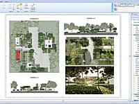
Edificius LAND is the BIM software for landscape architecture and garden design.

Comments & Reviews
Hussain Perozi
Hussain Perozi· 26 Dec 2015
Thanks for your great programs...
Similar Developers

6 softwareInterstudio

Architectural and land modeling, rendering, photogrammetry, CAD and geotechnical programs for Macintosh and Windows....

2 softwareCAD-Manufacturing Solutions, Inc.

CMS IntelliCAD is the intelligent, powerful and affordable full-featured 2D 3D DWG, DXF, DWF compatible CAD Software....

7 softwareSeismoSoft

Seismosoft was founded in 2002 with the aim of providing the earthquake engineering community with access to powerful and state-of-the-art analytical tools, and is now recognised as a leading enterprise in this field....

4 softwareUp2Specs Engineering

Online civil engineering calculations for storm water, culverts, gravity sewer, water distribution, traffic engineering, surveying, floors, foundations, retaining walls, reinforced concrete, structural steel, wood design, engineering economics and unit conversions...

3 softwareSoftree

Softree was born of a need to develop forestry road design software for the rocky & steep terrain of Canada's West Coast. Since then we have grown and expanded into other civil markets as well. Today our clients include consultants, governments, landowners, and other st...