CESDb > Water Resources > HEC-EFM
HEC-EFM screenshot
SOFTWARE :HEC-EFM
VERSION :5.0
PLATFORM :Windows
FILE SIZE :15.41 MB
LICENSE :GNU General Public License
DOWNLOADS :UserDownloads:614
Program Description

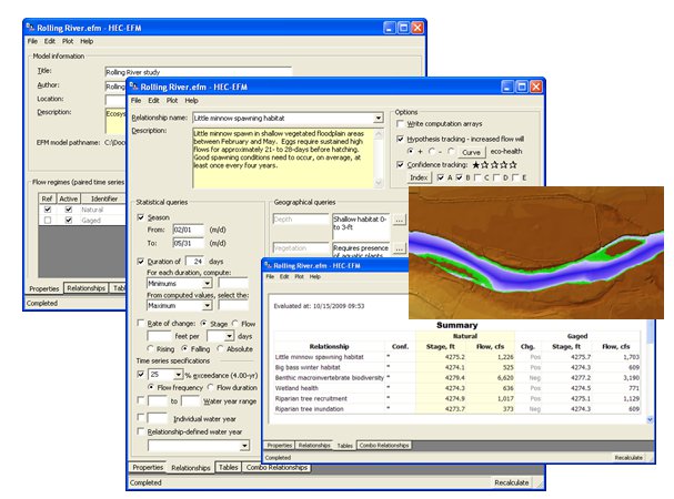
The Ecosystem Functions Model (HEC-EFM) is designed to help study teams determine ecosystem responses to changes in the flow regime of a river or connected wetland.

HEC-EFM analyses involve:

1) statistical analyses of relationships between hydrology and ecology,

2) hydraulic modeling, and

3) use of Geographic Information Systems (GIS) to display results and other relevant spatial data.

Through this process, study teams will be able to visualize and define existing ecologic conditions, highlight promising restoration sites, and assess and rank alternatives according to predicted changes in different aspects of the ecosystem.

HEC-EFM has many strengths, most notably

1) it is capable of testing ecological change for any number of relationships and flow regimes,

2) it links ecology with established hydrologic, hydraulic, and GIS tools, and

3) it can be applied quickly, inexpensively, and can incorporate expert knowledge.

HEC-EFM is also a generic software tool, applicable to a wide range of riverine and wetland ecosystems.

* HEC-EFM download link provides gnu general public license version of the software.

Similar Software
HEC-ResPRM Version:1.0 · Hydrologic Engineering Center
HEC-ResPRM

Prescriptive Reservoir Model

HEC-ResPRM is a reservoir system operations optimization software package developed to assist planners, operators, and managers with reservoir operation planning and decision-making.

HEC-SSP Version:2.2 · Hydrologic Engineering Center
HEC-SSP

Statistical Analyses Of Hydrologic Data

Statistical Software Package (HEC-SSP) developed by the Hydrologic Engineering Center. This software allows you to perform statistical analyses of hydrologic data.

HEC-HMS Version:4.7.1 · Hydrologic Engineering Center
HEC-HMS

Hydrologic Modeling System

The Hydrologic Modeling System (HEC-HMS) is designed to simulate the complete hydrologic processes of dendritic watershed systems.

HEC-FIA Version:3.1 · Hydrologic Engineering Center
HEC-FIA

Flood Impact Analysis

The HEC-FIA Flood Impact Analysis software package analyzes the consequences from a flood event.

HEC-RAS Version:6.0 · Hydrologic Engineering Center
HEC-RAS

River Analysis System

HEC-RAS is designed to perform one-dimensional hydraulic calculations for a full network of natural and constructed channels.

Comments & Reviews

No comments yet. Be the first to comment.

Submit a review about HEC-EFM software with your social media profile

avatar
Rate This Software

No one has rated HEC-EFM yet. Be the first to rate this product.

Popular Programs

9025 hitsHEC-RAS 6.0

HEC-RAS is designed to perform one-dimensional hydraulic calculations for a full network of natural and constructed channels.

3834 hitsHEC-HMS 4.7.1

The Hydrologic Modeling System (HEC-HMS) is designed to simulate the complete hydrologic processes of dendritic watershed systems.

3698 hitsPMWIN 5.3.3

Processing Modflow version 5. 3 is included in the first edition of the book 3D-Groundwater Modeling with PMWIN published by Springer-Verlag.

3297 hitsAquiferWin32 6.0

Aquifer test analysis is an integral part of groundwater modeling, supplying critical hydraulic parameters to the model or other basic groundwater calculations.

New & Updated

24 DecSMS 13.1

SMS (Surface-water Modeling System) is a complete program for building and simulating surface water models from Aquaveo.

10 DecWMS 11.1

Aquaveo WMS (Watershed Modeling System) is a watershed computer simulation and modeling software application from Aquaveo. WMS is a all-in-one hydrologic and hydraulic solutions and pipe network tools.

3 DecGMS 10.5

GMS (Groundwater Modeling System) is water modeling application for building and simulating groundwater models from Aquaveo.

12 MarGSFLOW 2.1

GSFLOW is a coupled Groundwater and Surface-water FLOW model based on the integration of the USGS Precipitation-Runoff Modeling System (PRMS-V) and the USGS Modular Groundwater Flow Model (MODFLOW-2005 and MODFLOW-NWT).