HighRoad is an interactive graphical application for the geometric design of roads and highways. It makes use of the proven graphical interface of modern operating systems so you can use the program immediately without learning complicated commands or special formulae. You don't need to be a computer expert to use HighRoad - its icons and graphics make it intuitive and quick to use.
Road design is fast and interactive with HighRoad. Even complex design elements such as intersections and cul-de-sacs are automatically created for you. HighRoad's proven "embedded intelligence" ensures that these elements remain synchronised as you make adjustments to your design. While it has a great amount of intelligence built in, HighRoad also provides you with the flexibility to override its decisions when necessary. The elegant interface of HighRoad means that it can be used for a variety of civil engineering tasks. As well as road design for subdivisions, highway planning, highway relocation, haul roads, and widenings, it has also been used for drainage channels, pipelines, retention basins, conveyor routes, open cut mines, race courses, airport runways, and so on.
Technical specifications
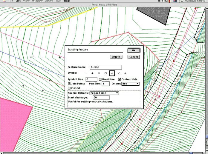
Digital terrain model
Ground model information is read from floppy disks or CDs, across a network, direct from data loggers or from the keyboard. A variety of common formats can be used - points list, DXF, MOSS, CivilCAD, compass & clinometer, cross sections, and raw readings from a range of data loggers. HighRoad joins feature strings automatically according to a feature library.
Typical sections
Typical sections are easily designed using a range of kerb, pavement and batter types. These can be selected from a palette of tools in the typical sections window. Simply select the edge and pavement types from the palette of tools and then locate these in the required position on the screen. Cut and paste from a typical section library making the design of complex carriageways easier.
Horizontal alignment
The ease of designing both horizontal and vertical alignments is one of the most impressive features of HighRoad. Multiple horizontal alignments are quickly laid out on the terrain model using the mouse. The horizontal curves, including transitions, are automatically calculated and inserted as you drag the horizontal intersection points.
Intersections
Intelligent intersection design automatically calculates the geometry and grading of an intersection or cul-de-sac. This is done instantly when it is first created it and whenever any adjustment is made to the roads that make up the intersection. The intersection can be dragged along the main road, or drag the main road and the intersection will go with it. It even automatically calculates the interaction between batter slopes.
Profile
The ground profile of the alignment is plotted on screen at a range of scales and vertical exaggeration. Intersection points are positioned using the mouse and can be easily and quickly moved to optimize the design. Vertical curves of parabolic form are automatically inserted and this enables you to quickly position a trial grade line on screen.
Cross sections
Cross sections at any chainage can be instantly displayed. Look quickly through a series of cross sections by simply pressing a button to view the next or previous section. The format of cross sections can be easily changed.
Plan
HighRoad uses the information provided in the typical section, profile and horizontal alignment to produce the plan view. Any changes made will be immediately reflected in the plan. You can choose which aspects of the terrain model and roads to display in the plan view.
Quantities
HighRoad calculates earthworks quantities or a mass haul diagram and allows for the topsoil stripping and strata such as rock.
Drive through simulation and 3D views
Once your design is complete, view a three dimensional drive-through simulation of the road. Various parameters such as driver's eye height and sight distance are adjusted to provide a realistic simulation and to check stopping sight distance requirements.
Drawings and data exchange
Plots of profile, cross sections and plan can be produced on a variety of plotters and printers. Drawings can be saved in PICT or DXF format. Terrain and/or design data can be exported in 3D DXF, MOSS GENIO, CLIP III, CivilCAD ASCII, GDL, Quickdraw 3D, Quicktime, PICT and text formats.
* To obtain an evaluation key for HighRoad, fill out the form at :
- http://en.interstudio.net/highroadev/evaluate.php
* HighRoad download link provides trial version of the software for Windows and Mac OS X.
Asphalt Thickness Design for Highways, Airports, Heavy Wheel Loads
An integrated pavement design suite for highways, streets, parking lots, airports, and industrial facilities supporting heavy wheel loads.
Domus. Cad is a program for architectural 3D design which allows you to face 3D design with the same simplicity as a traditional 2D design.
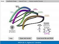
Plane Beahvior Of Arch With Geometric Imperfection
ArchPlane2D makes it possible to determine the resistant capacity of compressed and flexed arches with a double tee section, susceptible to buckling in their plane.
Roads, Open Mining, Garbage Dumps, Earth Displacement
The software ALE Advanced Land Editor is used by civil engineers, geologist and surveyors to perform the detail design of roads, open-pit mining, dams, garbage dumps, land rehabilitation, civil general design and so on.
Architectural Surveys, Mapping and Photogrammetry.
DigiCad 3D is an excellent tool for dealing with images, drawings, photographs of building, regular or irregular surfaces and maps.
Submit a review about HighRoad software with your social media profile