CESDb > Geotechnical Engineering > ALE Advanced Land Editor
ALE Advanced Land Editor screenshot
SOFTWARE :ALE Advanced Land Editor
DEVELOPER :ALE
VERSION :4.6
PLATFORM :Windows
FILE SIZE :6.02 MB
LICENSE :Demo
DOWNLOADS :UserDownloads:874
Legacy Software Notice:
Please be advised that ALE Advanced Land Editor is considered outdated or legacy, and it has reached the end of its support and update cycle. As a result, compatibility issues may arise, and its functionality cannot be guaranteed on modern computer systems.
Program Description

The software ALE Advanced Land Editor is used by civil engineers, geologist and surveyors to perform the detail design of roads, open-pit mining, dams, garbage dumps, land rehabilitation, civil general design and so on. ALE (Advanced Land Editor) is a powerful software to help civil design. It is developed from 2000 and now at its revision 4.

The ALE engine works by a 3D ground Modeler. Simple buildings are added both as a reference and visual evaluation of the general project.

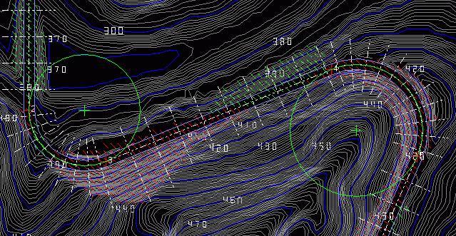
The program engine performs the complete land design and automatically makes the calculation of the cut and fill volumes inside a bounded area. The computation of digging and filling volumes may be performed by two different methods.

a) Cross Sections

b) Prisms

The result of the calculation, the detail report, the cross sections and the contour map are all available in real time. If requested, ALE automatically modifies the project to balance the cut and fill volumes.

* ALE Advanced Land Editor download link provides demo version of the software.

Similar Software
HighRoad Version:6.3 · Interstudio
HighRoad

Geometric Design of Roads and Highways

HighRoad is an interactive graphical application for the geometric design of roads and highways.

Thinwallres Open&Closed Version:2022 · Antonio Agüero
Thinwallres Open&Closed

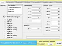
Elastic and Plastic Resistance of Open and Thin Walled Sections

Thinwallres Open&Closed application allows to determine the resistance capacity of open and closed thin-walled sections

Critical Depth Calculator in Open Channel Flows Version:0.1 · Hamed Mohammadi
Critical Depth Calculator in Open Channel Flows

Open Channel Hydraulics

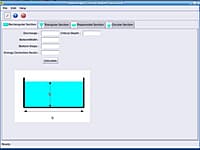
This is an application for calculating critical depth in open channels flow.

LateralK Version:4.0 · Novo Tech Software
LateralK

Earth Pressure Analysis

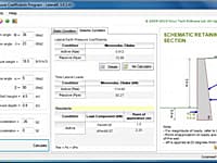
LateralK is a simple software for calculating lateral earth pressure coefficients and forces behind retaining walls in static and earthquake condition based on Rankine/ Coulumb formulas and also Mononobe/ Okabe methods.

Edificius LAND Version:BIM 2(m) · ACCA Software
Edificius LAND

BIM Landscape Design

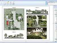
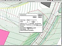
Edificius LAND is the BIM software for landscape architecture and garden design.

Comments & Reviews

No comments yet. Be the first to comment.

Submit a review about ALE Advanced Land Editor software with your social media profile

avatar
Rate This Software

ALE Advanced Land Editor has been rated 5.0 out of 5 points. A total of 1 votes cast and 0 users reviewed the software.

Popular Programs

13960 hitsPOLEFDN 2.3

POLEFDN is a spreadsheet program written in MS-Excel for the purpose of analysis of a pole foundation assuming the use of a rigid round pier which is assumed free at the top and subjected to lateral and vertical loads.

7806 hitsAllPile 7.19

AllPile is a Windows-based analysis program that handles virtually all types of piles, including steel pipes, H-piles, pre-cast concrete piles, auger-cast piles, drilled shafts, timber piles, jetted piles, tapered piles, piers with bell, micropiles (minipiles), uplift anchors, uplift plate, and shallow foundations.

7588 hitsDips 8.0

Dips is designed for the interactive analysis of orientation based geological data.

6918 hitsSlide 9.0

Slide is the most comprehensive slope stability analysis software available, complete with finite element groundwater seepage analysis, rapid drawdown, sensitivity and probabilistic analysis and support design.

New & Updated

14 JanRetainX 2022

Free retaining wall design software that fully works in a web browser. Create a stable retaining wall design using state-of-the-art software without downloading software.

13 JanDartis SPT Correlations 1.1.0

Dartis SPT is a powerful, user-friendly software for correlating soil properties from SPT blow counts. We have gone through many papers and geotechnical reference books and collected over 200 SPT correlations with various soil properties.

25 NovGaeaSynergy 4.0

GaeaSynergy is an application suite for geoscientific analyses, mapping, data display and data management. The program can be used to evaluate contaminants, soil and rock properties, mineral deposits, and oil and gas deposits.

18 NovWinLog 4.0

The WinLoG extension module of GaeaSynergy can be used to quickly and easily create, edit and print boring logs, borehole logs and well logs for a variety of industries.